Measure by Measure: Reflections on Building a Quiz Map for Critical Caribbean Digital Pedagogy
Resumen (en traducción)
Este artículo reflexiona acerca de la creación de un cuestionario de mapas digitales que fue diseñado para ayudar a los estudiantes a comprometerse con la representación del Caribe en el espacio digital. Al emerger de los talleres de Visiones del Caribe – una iniciativa de humanidades digitales que emplea los mapas y archivos para enseñar la historia, cultura y cartografía caribeña – esta herramienta responde a las preguntas de los estudiantes sobre los límites espaciales de la región. Este cuestionario invita a los estudiantes a seleccionar en un mapa de los países y territorios que consideran parte del Caribe, lo que fomenta una reflexión sobre la diversidad de perspectivas que dan forma a la identidad caribeña. Al utilizar la teoría de la cartografía crítica y la pedagogía digital, el proyecto plantea que la cartografía no es neutra sino una cuestión política y ética influida por los legados coloniales, los idiomas y las ideologías. Aplicando el marco teórico de Antonio Gaztambide-Géigel que define el Caribe a través de cuatro categorías: 1) etnohistoria, 2) geopolítica, 3) «Gran colonial», 4) lo plantación-cultural, esta versión beta del cuestionario de mapas emplea los polígonos para codificar un programa que define ciertos vectores como caribeños. La producción de esta herramienta inspira una reflexión sobre la ética de la medida. Los creadores de este proyecto consideran la diferencia entre el mapa topográfico interactivo y el mapa estándar político con respecto a la caprichosidad de la representación geográfica, lo que reaviva discusiones sobre las fronteras superpuestas (por ejemplo La Española o el renombrado Golfo de América) y los marcos lingüísticos competidores (como el Taíno). El proceso de este proyecto revela cómo las herramientas digitales pueden reforzar y desafiar las narrativas dominantes. Los creadores proponen que las prácticas de contra cartografía ofrecen una vía significativa para reimaginar el Caribe como un espacio plural y en evolución, lo que profundiza en el compromiso pedagógico a la vez de poner en primer plano las implicaciones de la representación digital.
Introduction: Mapping the Caribbean
In Kei Miller’s thought-provoking poem The Cartographer Tries to Map a Way to Zion,[1] a Rastaman and the eponymous mapmaker engage in a sustained dialogue. Within the Jamaican translocal context, to “reason” is to gather in social company and participate, often with enthusiasm, in critical rhetorical exchange. Reasoning involves active listening and not just debating, as animated parties ponder political problems from stubborn standpoints. In Miller’s poetic fabulation, the title destination, “Zion,” invokes Rastafarianism in general and an aspirational image of a geographically realized heaven in particular. However, the real crux of this creative dialogue between a cartographer and a Rastaman is whether or not mapmaking lives up to the divine goal of zero bias. The cartographer insists that “What I do is science. I show // the earth as it is, without bias.” The Rastaman counters that the map is skewed towards hegemony because “the mapmaker’s work is to make visible all them things that shoulda never exist in the first place like the conquest of pirates, like borders, like the viral spread of governments.”[2] This tension between the map as instrument of legibility and tool of hegemony, has been taken up in Caribbean digital scholarship as well. Bonilla and Hantel argue that geographic visualization has historically reproduced the nation-state as the natural unit of politics, and calls for digital experiments that can “retheorize the meaning of sovereignty itself.”[3]
Like the Rastaman in Miller’s poem, this article interrogates what a map makes visible and invisible. Specifically, we describe, measure by measure, the process of conceptualizing, coding, then constructing an interactive digital map designed to serve as a diagnostic quiz for young learners being introduced to the history of the Caribbean. This project, developed as a contribution to Visiones del Caribe,[4] an interinstitutional education platform run by academic and technical collaborators from Bowling Green State University (BGSU), Florida International University (FIU), and the University of Miami (UM), engages users in participatory map-making and geographic inquiry. Visiones del Caribe uses digital mapping tools to visually and interactively teach elementary and primary school students about the extensive history of the Caribbean. This map-based digital humanities platform, which has received curricular funding from the Digital Library of the Caribbean at the University of Florida (dLOC), supports education workshops about Caribbean history and civics for young students, teacher candidates, and in-service teachers located in the region. Initially, the PDFs were designed for teacher candidates, they are labeled as such, but we also use them when providing professional development sessions to in-service teachers. To date, site-specific workshops have been held at grade schools in Miami, Florida; San Juan, Puerto Rico; Santiago de los Caballeros, Dominican Republic; and Spanish Town, Jamaica and with teacher candidates and in-service teachers at the University of Puerto Rico, San Juan.
Prior to the building of a digital quiz map, Visiones workshops have begun with the act of putting colored pencils to paper as a tactile gesture toward place. Whether working with students, teacher candidates, or in-service teachers, all were first invited to sketch a map depicting their visions of the Caribbean. This cartographic exposition echoes the conclusion of Kei Miller’s poem, when the Rastaman implores the cartographer: “draw me a map of what you see // then I will draw a map of what you never see // and guess me whose map will be bigger than whose? // Guess me whose map will tell the larger truth?”[5] The goal of these workshops was to expand their understanding of the history, geography, and historiography of the region. After the preliminary sketch work, students were introduced to physical and digital copies of primary source materials such as sixteenth century maps, letters, ethnographies, travel diaries, paintings, isolarii and other important historical sources from former European colonial administrators writing about and within the Caribbean; along with images of cultural artifacts (e.g., a cemí) and video documentaries of recreated Taíno villages. The Visiones team internally scans the primary source media; then, we upload and pin scans onto the main map of the Visiones website via its user-friendly built-in features. Digital pins were affixed to the generic location where the primary source was authored, creating a recognizably geographic repository of the primary sources. The platform boasts a gallery of student drawings as well, and the option for students to create their own maps with personal pins, contributing to an archive of both collective and independent virtual models of Caribbean history.
These archival materials are not just a repository to scroll through. In workshops, the geographic pins function as anchor points for guided discussion, close reading of primary sources, and independent student research. For instance, a teacher might invite students to read a sixteenth-century letter pinned to Havana alongside a contemporary photograph, asking them to compare how the island is described across centuries. This close-reading practice connects the digital archive to the critical inquiry skills central to the Visiones curriculum.
Visiones demonstrates that mapmaking, as an analog[6] and/or digital[7] form of data visualization, can be a pedagogical medium,[8] not just a political weapon, that presents ways of knowing through geographic data. Mapping has supported the programmatic endeavors of this initiative by leveraging multimodal computational affordances to enhance the learning experiences of multiple cohorts of young persons residing in the Caribbean region.[9] Youth participants of the workshops move from print media to a networked interface, from archived historiography to digital cartography, underscoring interactive and innovative modes of teaching that are central to accomplishing the mission of this program. Furthermore, workshops advanced a central notion of charting the Caribbean not as a static act, but as a digital (tactile, via human digits, and online) mode of embodied inquiry.
Over time, our interactions with students led us to look for more systematic ways to measure their perceptions of the Caribbean. We devised a tool to visualize and assess pupils’ spatial and cultural definitions of the region—a digital quiz map that asks participants, k-12 students, teacher candidates (undergraduate or/and graduate), and in-service teachers, to identify the countries and territories that they consider to be a part of the Caribbean. This activity, which prompts individual reflection and collective discussion, emerged from a recurring theme in our workshops: participants’ uncertainty and curiosity about the region’s boundaries and their meanings. For example, when participants drew their initial conceptions of the Caribbean, some students only drew an island with water around it. A few sketched el Caribe insular (i.e., the Greater and Lesser Antilles archipelagos). Rarely have we had a participant draw el Gran Caribe (i.e., the Caribbean Basin).[10] This led us to ponder how they could engage a fuller map of the Caribbean. Therefore, we sought to design a map to capture diverse and sometimes contradictory understandings of the Caribbean. Our solution was to build a quiz that could act as both a pedagogical tool and a research method, allowing educators to engage critically with learners’ conceptualizations of place, identity, and belonging. Therefore, the quiz functions as a teacher- and student-facing diagnostic and reflective tool that can be paired with pedagogical scaffolding to enable different audiences to engage meaningfully. Younger students might need the support of a teacher to engage in the quiz and workshops,[11] whereas older students can utilize the quiz independently. The digital quiz map begins with a single alliterative prompt: “Click the Caribbean: select all the places on this map that you consider to be a part of the Caribbean region.”
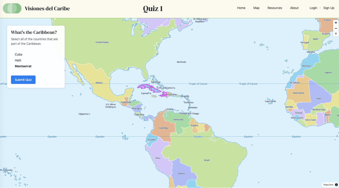
This article explores the methodology and theory behind the digital quiz map’s design. The discussion is divided into three sections: the first section details frameworks that informed the quiz map’s technical design; the second section further explores the limits of modeling the Caribbean; and the third section discusses the sustainability of the project infrastructure. In many ways, we teachers of the workshops became the students. As a new contribution to the Visiones platform, the digital quiz map introduced opportunities and challenges. What does it mean to “map” the Caribbean as a consolidated, clickable territory—and who gets to decide? The central tension revolved around our use of polygons to algorithmically designate certain areas and not others as “Caribbean,” and how this intersects with contested definitions of Caribbean space as well as subjective software. Accordingly, we examine the ways in which historical, linguistic, and sociotechnical contexts shape the contours of Caribbean cartography. We discuss three frameworks; principally, the quaternary model presented by Antonio Gaztambide-Géigel in his article entitled, “The Invention of the Caribbean in the 20th Century (The Definitions of the Caribbean as a Historical and Methodological Problem),”[12] alongside interventions by Charles Wagley and Kamau Brathwaite, who supplied critical models that guided our effort to construct a catch-all representation of the Caribbean. No comprehensive, scholarly map of the Caribbean exists online; a testament to the technically ambitious and intellectually ambiguous nature of such a cartographic undertaking. Yet, across its iterations, this quiz provided lessons for what such a map could look like in its digital and pedagogical realization. From the polygon prototype we established that technical precision does not equal geographic truth. From the algorithmic (MapLibre) migration we established that open-source tools carry their own epistemological constraints. Thus, the quiz functions as a provocation, not a resolution, and students’ drawings, quiz data, and post quiz discussion together form an archive of multiple Caribbean cartographies rather than a test with a single correct answer.
Section I: Coding the Caribbean
Echoing the opening exercise of Visiones del Caribe workshops—wherein students sketch maps of their visions of the Caribbean—the computational construction of a digital map with quiz-like interactivity became its own exercise in creativity, critical inquiry, and conscious reflection. In this case, a blank file in the web platform’s GitHub repository served as our sheet of paper; polygons became our colored pencils; and geodata shaped by Caribbean Studies-adapted frameworks formed the inputs to the algorithm we wrote in JavaScript.
Drawing with code was an intellectual and ethical challenge. Even as teachers of the Caribbean, we found ourselves in the learner’s seat. The problem at hand was to draw not just “a map” of the Caribbean, but “the map.” This map of the Caribbean required sufficient empirical and epistemological merit for incorporation into workshops designed to assess students across diverse international grade schools on their understanding of the region and its representative locations. Such a digital quiz map would inculcate as much as it would inspire, and reify as much as it would reason about, particular geographic notions of the Caribbean.
The quiz could be at least deployed in two complementary modes. In teacher-mediated workshops, an instructor introduces the Gaztambide-Géigel definitions of the region after students take the quiz. For example, after taking the quiz, a teacher of younger students would display a visual layering of the four Caribbean categories on a projected map or show four different maps, one of each category and have students explore the similarities and differences to better learn the definitions of each category. This teacher-led post submission discussion of the framework descriptions becomes the basis for guided discussion and analysis of students’ responses. In the standalone self-guided mode, older or more independent users encounter the quiz and its classification feedback without prior instruction, engaging the critical frameworks as a form of self-directed inquiry. Both modes have the same goal: prompting students to interrogate the assumptions ingrained in their own geographic knowledge.
Critical Caribbean Digital Pedagogy (CCDP)[13] was a framework that guided our design intentions for this project. CCDP was introduced to the collaborators of Visiones del Caribe in June 2024 at the University of Miami during the Summer Institute organized by the Caribbean Digital Scholarship Collective (CDSsi). By the end of the week-long program, fellows in the CCDP course collated a list of nearly a dozen definitions of the values meant to be conveyed by CCDP. One such definition proposed by this article’s co‑author Ra Bacchus was as follows:
CCDP is intended to be a respectful, consent-based, historically-informed, and geographically situated approach towards navigating the challenges and opportunities of leveraging digital technologies in, of, or with the Caribbean as a site (no pun intended) of possibilities that reach beyond neo/imperial concepts of modernity. ‘Stepping into the terms,’ to borrow language from functional code studies, CCDP reminds us that the Caribbean is a site of tensions, not just interventions; and differences, not regional homogeneity. Reflexiveness, not just outwardness, is at the core of what it means to critically engage Caribbean-facing pedagogy through technology. CCDP affirms that the personal is political, and confirms that our digital engagements with the Caribbean have to first take care of differences at the level of the translocal (not the global) and the interpersonal (not the paternal) through complexity, dialogue, respect, and self-awareness.
Bringing an ethic of care to this computational endeavor reflected our commitment to enacting CCDP. At the outset, we needed to be transparent about the dialectical design choices of inclusion/exclusion, selection/deselection, and validation/negation that would structure the final result of our attempts to produce an exhaustive representation of the Caribbean in digital space. To this end, we were keen to leverage published academic discourse about what defines the Caribbean, and not personal preference, as the departure point for the quiz’s design. This teleological approach would allow us to maintain academic integrity by making visible any areas where we deviated from established institutional knowledge. Moreover, a discursive start helped us document ways we sought to contribute to existing knowledge in our pursuit of a capacious definition and digital representation of this region.
A little more than two decades ago, before we dreamt of being digital cartographers of the Caribbean, Antonio Gaztambide-Géigel published “The Invention of the Caribbean in the 20th Century: The Definitions of the Caribbean as a Historical and Methodological Problem .”[14] Synthesizing historiography, foreign policy, and emerging thought in Caribbean Studies, this prescient article described “three main tendencies that group the definitions of the Caribbean as a geographic region (that is, the supranational conceptualization of a group of land masses).”[15]
(A) the insular or ethno-historic Caribbean;
(B) the geopolitical Caribbean;
(C) the Greater Caribbean or Caribbean Basin.
To this triplet, Gaztambide-Géigel added a fourth category of the Caribbean:
(D) the cultural Caribbean, or Central Afro-America.[16]
Four categories, four buckets drawn directly from Gaztambide-Géigel’s article guided our organization of geodata. These four Caribbeans provided a conceptual scaffold for deciding which places to include, and why. To this end, we coded a web algorithm to parse through a spreadsheet containing a list of key locations and their geospatial coordinates. The underlying spreadsheet was populated using Gaztambide‑Géigel’s quaternary framework as the vector for our extensive survey of Caribbean locations. If a user selected a place on the web map whose latitude and longitude matched a point in the spreadsheet, then the quiz map would register the mouse-click as correct and award the student a point.
In this way, rather than marking users’ selections as “right” or “wrong,” the quiz classifies each selection according to one of these four frameworks. When a user clicks a location whose coordinates fall within a recorded polygon, the algorithm registers the selection and assigns it to the appropriate Gaztambide-Géigel category. After submitting the quiz, users see which framework or frameworks their selections align with. For example, “Based on your selections, your understanding of the Caribbean most closely aligns with: Island Caribbean.” Users are then provided a definition of Island Caribbean. Users receive grade-level appropriate definitions of the four categories. Users ages 8-10 see “Island Caribbean – These are mostly the islands, like Cuba, Jamaica, Puerto Rico, and others nearby. Long ago, people there worked on sugar plantations, and their history connects them.” Older users, for example ages 14-18 see “Island Caribbean (Insular or Ethno-Historical).” This version focuses on the Antilles or West Indies, the islands most people think of as “the Caribbean.” Sometimes it includes nearby regions like the Bahamas, Bermuda, Belize, and the Guianas. Historians use this idea because it reflects how people from these islands have long seen themselves: connected through the history of slavery, sugar plantations, and creole cultures. These different age-level appropriate definitions turn the classification exercise into a scaffold for critical discussion rather than a binary judgment.
Going group by group, Gaztambide‑Géigel first explained that the insular Caribbean “tends to be synonymous with the Antilles and the West Indies” and alludes to struggles for independence as well as regional identity in this region.[17] As such, we combed atlases of the archipelagic Antilles and compiled a comprehensive roster of polities that nominally comprise the Antillean Caribbean, beginning with the larger island nations of the Greater Antilles and continuing to the smaller island states and territories of the Lesser Antilles.[18] Notably, according to Gaztambide‑Géigel, “the Guyanas and Belize” are folded into the insular category because of their shared colonial, cultural, and geopolitical entanglements in the region.[19] This underscores how the definition of the insular Caribbean pushes past narrower, strictly oceanic representations to include mainland territories that are part of the West Indies’ historiography. Accordingly, our list identified: 1) Anguilla, 2) Antigua and Barbuda, 3) Aruba, 4) The Bahamas, 5) Barbados, 6) Belize, 7) Bermuda, 8) Bonaire, 9) British Virgin Islands, 10) Cayman Islands, 11) Cuba, 12) Curaçao, 13) Dominica, 14) Dominican Republic, 15) French Guiana, 16) Grenada, 17) Guadeloupe, 18) Guyana, 19) Haiti, 20) Jamaica, 21) Martinique, 22) Montserrat, 23) Puerto Rico, 24) Saba, 25) Saint Barthélemy, 26) Saint Kitts and Nevis, 27) Saint Lucia, 28) Saint Martin, 29) Saint Vincent and the Grenadines, 30) Sint Eustatius, 31) Suriname, 32) Trinidad and Tobago, 33) Turks and Caicos Islands, and 34) U.S. Virgin Islands.
Having noted the loci that are inherent to Gaztambide‑Géigel’s definition of the insular Caribbean, our next step involved leveraging ArcGIS mapping software to obtain quantitative identifiers for each place. In ArcGIS, we drew numerous polygons to create irregular quadrilaterals that delineated each location of interest. If a polygon surrounded an area in the Caribbean, then four two-dimensional Cartesian coordinates were recorded and added to the spreadsheet. The pairwise points reflected the top-left, top-right, bottom-left, and bottom-right corners of the polygon and corresponded to the latitude (X) and longitude (Y) of the polity’s boundaries. Reading numerical data, our JavaScript algorithm evaluated user clicks against these intervals. Clicking within a recorded interval signifies a successful selection, so the program adds a point to a counter. While we aimed to retrofit green landmasses into the polygons, this was an uneven process, similar to how colonial borders haphazardly cut up otherwise fluid or unperturbed natural boundaries. For example, The Bahamas, with its scattered archipelago, required a polygon spanning sea and land, thereby acknowledging the liminal incongruity of its ontology in terms of both geography and geometry.
Furthermore, the polygon strategy, while pragmatic for computational purposes, obscures the lived realities of borders in the Caribbean. By reducing territories to Cartesian coordinates, the web algorithm inevitably erases the fluidity, contestation, and violence that mark many of the region’s frontiers. Nowhere is this clearer than on the island of Hispaniola, where the border between the Dominican Republic and Haiti is measured variously as 171 or 224 miles depending on cartographic scale, and has historically been less of a line than a shifting zone of negotiation, movement, and trauma.[20] The transformation from a porous borderland to a militarized hard-border, particularly under the Trujillo dictatorship, underscores how border-making is not simply geometric but deeply racialized, political, and violent.[21] By dividing Hispaniola into neat, bounded quadrilaterals, our polygonal inscriptions efface these histories of contestation and their enduring socio political ramifications. These limitations echo the cartographic challenges Bonilla and Hantel confronted when building their own digital map of the Caribbean. They found that standard projections systematically obscured non-independent territories and forced Caribbean societies into the visual logic of the Westphalian nation state.
Recent disputes over the bordering Massacre River further exemplify this problem. The 1929 Treaty of Peace, Friendship, and Arbitration sought to stabilize the frontier by codifying “equitable” water rights for both nations,[22] yet recurring tensions—most recently around Haiti’s construction of an irrigation canal—reveal how fragile such agreements remain.[23] As Hogue notes, Dominican border closures in 2023 illustrate how cartographic lines can be mobilized to justify exclusionary policies, often at the expense of vulnerable Haitian migrants.[24] Here, the border is not a polygonal box enclosing a space, but an active site of contestation where legal frameworks, resource scarcity, and racialized histories intersect. By coding the Caribbean via polygons, we risk reproducing a sanitized geography that cannot register the friction of rivers, treaties, massacres, and migrant crossings that continue to animate Hispaniola’s border.
In pedagogical terms, the case of Hispaniola reminds us that borders are not simply lines to be memorized but lived realities that embody unequal power, historical trauma, and contested sovereignties. The neat polygons of our quiz interface, while functional for click-based recognition, risked conveying to students a false sense of precision and permanence. To counter this directly on the platform, we propose adding boundary uncertainty annotations to contested borders. For example, in the future, clicking on the DR-Haiti border area would trigger a contextual note referencing the Massacre River dispute and the legacy of the Parsley Massacre, surfacing the historical complexity that the polygon itself cannot represent. The shift to MapLibre (discussed in the Conclusion) partially addresses the false-precision problem by using real-world vector boundaries rather than hand drawn rectangles, while acknowledging that MapLibre’s automated boundaries carry their own authority effects.
If Hispaniola foregrounds how borders on a single island become layered with violence, memory, and contested meaning, Gaztambide-Géigel invites us to widen the lens. In addition to the insular Caribbean, Gaztambide‑Géigel described the geopolitical Caribbean as a larger concentric circle defining the region categorically.[25] Bridging historiography with an analysis of mid-twentieth century U.S. foreign policy, the study argues that “the geopolitical Caribbean refers to the insular Caribbean, Central America and Panamá, especially after 1945” because “this one places the emphasis on regions where most of the U.S. military interventions took place.”[26] Gaztambide‑Géigel acknowledges that the geopolitical group introduces key areas that would otherwise be considered Latin America: “At least until a few decades ago, the U.S. government’s ‘Caribbean’ policy was not only indistinguishable from its Latin American policy, but to a great extent it was its Latin American policy”[27] because “policymakers looked at Latin America—and to some degree still do—through the looking-glass of their relations with, and perceptions of, the Caribbean.”[28] Gaztambide-Géigel pointed out that “‘Caribbean’ diplomacy is understood as the one aimed at the republics,” which implicated the Central American “banana republics” as part of the Caribbean.[29] This led us to include: 35) El Salvador, 36) Guatemala, 37) Nicaragua, 38) Panamá, 39) Hondurás, and 40) Costa Rica.
Notably, we added Hondurás and Costa Rica, countries that Gaztambide‑Géigel does not explicitly name, yet ones that Acker and Echeverri-Gent have directly connected to the external grouping of their neighboring nations as banana industries ripe for neoliberal interventionism.[30] In Gaztambide‑Géigel’s reading of the U.S. geopolitical imaginary, “the Caribbean tends to coincide with the vision of the Caribbean as Mesoamérica or a “central” America standing between the North and the South.”[31] Consequently, we added six more locations to our GIS data methodology for inclusion in the quiz map, modeling a transhistorical representation of the Caribbean in the wake of Rooseveltian “big stick” foreign policies. Notably, Bonilla and Hantel cautions that any digital map of the Caribbean risks flattening the distinction that most Caribbean societies are not sovereign nation-states but dependencies, territories, and departments.[32] A quiz that awards equal “points” for clicking Puerto Rico or Martinique alongside Cuba or Jamaica may inadvertently reproduce the very nation-state logic that obscures Caribbean political complexity.
Joining the insular and the geopolitical Caribbean with a concept of “the Greater Caribbean or Caribbean Basin,” Gaztambide‑Géigel added Venezuela and portions of Colombia and México.[33] These three locations reflect the emergence of a political-economic kinship with the Caribbean as a form of what Gaztambide‑Géigel called “the geopolitics of resistance” that juxtaposes “the geopolitics of hegemony.”[34] These ‘regional powers’—Colombia, México, and Venezuela—activated with Panamá their “‘preeminent interests’ in the region as a reaction to the U.S. counteroffensive.”[35] Though Gaztambide-Géigel insisted that “at least important parts of Colombia and Venezuela have always been Caribbean,” it was “the dominant groups of those countries [that] wanted to get close to the Caribbean again for the sake of their own geopolitical ambitions or fears.”[36]
Despite some scholars like Marco Meniketti questioning, “is Mexico a Caribbean nation?,”[37] we decided to move forward with including Mexico based on Gaztambide's argument. For the purposes of this project, we did not distinguish which parts of the mainland Gran Caribe were uniquely Caribbean; a student only needed to select Colombia, México, and Venezuela on the web map to prove the point and procure points from the mouse-sensistive algorithm. However, we recognize and highlight the unilateral effect of our decision because the quiz in its current state cannot speak to the underlying intranational complexity. A user who selects Mé xico for instance, will receive supplementary clarifying information in a future iteration of the post-quiz feedback explaining which regions of the country share Caribbean cultural and historical ties, and why the selection registers under the Greater Caribbean rather than the insular framework. Thus, this case encourages future iterations of the quiz to be more intentional; i.e., to respond to user selections of México and similar mainland territories with supplementary clarifying information about translocal context.
Upon reflection, though we had been familiar with Gaztambide-Géigel for some time, each definition pushed us to broaden our understanding of what should be included in the digital quiz. If we followed only the insular definition, for instance, then we risked excluding groups of people who might consider themselves as Caribbean. This led us to reconsider our working definitions and to revisit Gaztambide-Géigel’s ideas as an iterative process of discursive design. Oscillating between Gaztambide‑Géigel’s definitions and technical geodata, we realized that if we considered the geopolitical Caribbean, then we had to include Central America; and if we considered the greater Caribbean basin, then we had to include even more, which led us to mainlands. By encoding el Gran Caribe with the geopolitical and insular Caribbeans, our geodata methodology expanded to include forty-three initial locations. It was not until we realized that we included Miami as part of the Caribbean in our workshops that the first three definitions were still not robust enough. We were left wondering if we had shortchanged the complexity of the Caribbean because we did not include the cultural Caribbean.
Section II: Envisioning the Caribbean
It bears noting that Gaztambide‑Géigel’s textual representation of three initial tendencies for charting the Caribbean already challenged the cartographic archive of Caribbean Studies. In the publishing of Caribbean Studies: A Symposium, edited by Vera Rubin, a variety of scholars contributed essays that spoke to the emerging discipline of Caribbean Studies.[38] Ironically, despite interventions by scholars such as Preston E. James or Charles Wagley—whose essay “Plantation America: A Cultural Sphere,”[39] inspired Gaztambide‑Géigel’s inclusion of a fourth category, the cultural Caribbean or Central Afro-America—the series opens with a document-sized figure captioned “Map of the Caribbean.”[40] This featured map neglected to label Venezuela, a polity that Preston E. James discusses centrally in his in-volume essay, “Man-Land Relations in the Caribbean Area,” due to Venezuela’s shared sugarcane plantation history.[41] Nor does the book’s opening map look beyond south Florida to Louisiana, a location that fits squarely within a framework of the Caribbean that references southern Afro-America.
These omissions do not only speak to certain epistemological gaps that ought to be filled in the emergent field of Caribbean Studies, a field produced out of political-economic need to respond to the aftermath of trans-Atlantic slavery and its shaping of western modernity.[42] Cartographic discrepancies also prove that representations of the Caribbean are historically negotiated. The field has faced a methodological problem; Caribbeanists must adapt methods from the social sciences, cultural studies, the information sciences, and literary studies to redress analytical challenges and to define the working apparatuses of this burgeoning discipline. Gaztambide‑Géigel topically refers to the Caribbean as a twentieth century invention. This section considers how linguistic and historical frameworks inform cartographic inventions that purport to represent Caribbean space.
In the Cuban Heritage Collection (CHC) of the University of Miami, two separate maps of the Caribbean Sea evidence the shifting names of this marine space. Like the renaming of the Gulf of Mexico to the Gulf of America, transimperial influence shaped the naming of the Caribbean Sea. In one map from the sixteenth century, the sea was labeled as the “Archipelago del Mexico.”[43] By contrast, an eighteenth century map representing the same section of sea was labeled as “Archipelago delle Antilles.”[44] Variations on the representation of the Caribbean have been an issue for over two hundred years. Gaztambide‑Géigel clarifies that “the Antillean Caribbean still gets confused with the West Indies, just as it was two hundred years ago. Why? Simply because—as reflected in the previous quote—Great Britain translated the Spanish imperial name. And up until some fifty years ago, English-speakers from both sides of the Atlantic—including those in the Caribbean itself—referred to the Antilles exclusively as the West Indies.”[45] Gaztambide‑Géigel’s political analysis resolves that “the West Indies were transformed into the Caribbean around the same time as the Antilles were, yet another sign of the imperial transitions, this time during the Second World War.”[46]
These historical transformations remind us that naming the Caribbean has never been a neutral act but one mediated by imperial translation, cartographic omission, and disciplinary invention. Yet alongside these colonial archives exists another archive—one inscribed not on parchment but in oral traditions and place-based languages. The names of the islands themselves also bear witness to the Taíno ecolinguistic worldview, which privileged multiplicity and intimacy with place. The ancestral names of the islands—Borikén (Puerto Rico), Ayiti (Haiti), Kiskeya (the eastern half of Hispaniola), and Cubanacán (Cuba)—are more than toponyms; they encode the Taíno ecolinguistic worldview that Fisk describes as grounded in “environmental relationalities.”[47] Each designation is relational rather than merely referential, emerging from intimate knowledge of the land. For example, Ayiti, meaning “land of high mountains,” reflects an embodied perception of topography as identity, while Borikén portrays Puerto Rico as “the great land of the valiant and noble lord.” By restoring these names to our maps, we do more than recover precolonial labels—we acknowledge a language ideology that resisted flattening the world into single designations. In Fisk’s terms, Taíno naming practices reveal a preference for naming multiplicity, privileging layered understandings of place over the univocality imposed by European cartography.[48] This principle of multiplicity is already legible in early colonial sources such as Ramón Pané’s Relación acerca de las antigüedades de los indios, the first ethnographic text of the Americas, where the friar carefully recorded Taíno myths, cosmologies, and naming practices that anchored culture in land and kinship.[49]
Fisk’s ecolinguistic analysis demonstrates that multiplicity was not accidental but fundamental: the more intimate Taíno communities were with a landscape or organism, the more names they developed to describe it. Applying this insight to the islands of the Caribbean, we can see how Taíno naming systems embodied biocultural intimacy at the scale of geography itself. Unlike the Linnaean system, which collapses diversity into rigid taxonomies, Taíno names for islands reflected an ontology where landscapes were kin, storied, and multiple. Pané’s Relación—preserved through Bartolomé de las Casas, Pedro Mártir de Anglería, and Alfonso de Ulloa’s Italian translation—reminds us how fragile but also how resilient this archive of Indigenous language has been. To reinscribe Borikén, Ayiti, Kiskeya, and Cubanacán alongside or even in place of their colonial names[50] is therefore to engage in what Fisk calls language reclamation: operationalizing the ideology of multiplicity as a decolonial practice. In doing so, we move beyond mere commemoration and toward restoring a worldview in which naming is an act of relation, memory, and sovereignty.
The tension between Indigenous multiplicity and colonial taxonomy also reverberates in modern debates about regional identity. Nowhere is this clearer than in Puerto Rico, where the layering of names—from Borikén to San Juan Bautista to Porto Rico—reveals how language can both root communities in ancestral geographies and subject them to external categorizations. Puerto Rico provides a direct case study on the troubled nature of these shifting appellatives. As the Puerto Rican writer Edgardo Rodríguez Juliá expressed:
For us, Puerto Ricans, the term antillanía [Antillenaism] has a complete meaning, not so the terms caribeño [Caribbean] or carobeñidad [Caribbeanness]. The former congregates us within the historical and cultural experience shared with the Greater Antilles, the latter—the Caribbean—submits us to a suprahistorical category, an invention of the sociological, anthropological, or ethnological objectivity of an Anglophone origin, an objectivity that always works against the colonized, as Fanón pointed out.[51]
How do we design a map of the Caribbean that takes into account such user experiences? Perhaps one response to this reflection relates to Gaztambide‑Géigel’s own motivation to expand the three tendencies of categorizing the Caribbean to include “the cultural Caribbean.” This sphere recognizes Caribbean mobilities, including Afro-descendant diasporic communities living in Europe and North America, as a result of the common denominator of the Plantation System. Noting the history of the plantation in the Caribbean, Gaztambide‑Géigel does well to include the U.S. south, Brazil, and Caribbean migrant communities in his definition of the Cultural Caribbean. Although he never mentions Canada, we expanded on his definition to include this country because of the strong Caribbean cultural lineage and demographic presence in places like Toronto.
This Plantation model is one that Gaztambide‑Géigel adopted from Charles Wagley, who divided “the hemisphere into three cultural spheres: Euro-America or the South Cone; Indo-America; and Plantation America.”[52] Plantation America emphasizes cultural continuities across Afro-descendant populations.[53] As Marco Meniketti states in his 2009 essay, “Boundaries, Borders, and Reference Points: The Caribbean Defined as Geographic Region and Social Reality,” in which he defines the Caribbean through a concept of geo-social identification, “if we include the islands of the Bahamas, can we exclude the Florida Keys, or Florida itself? If patterns of immigration are considered, New York and Miami, or perhaps London and Paris come under the sphere of Caribbean influence, each with populations of West Indians exceeding that of some of the islands.”[54] For our quiz program, it may not be possible to record all the places in which Afro-Caribbean migrant communities reside, places Gruez describes in her framing of the Black Atlantic and circum-Atlantic as cultural “geographies other than the national.”[55] That said, a representation of the cultural Caribbean would benefit from autoethnography, or reflexive opportunities for self-identification, and not scholarly determination. As a design method, this keeps the user-in-the-loop in order to achieve a more comprehensive representation of the region from the lens of lived experiences. In addition to coding Brazil as Caribbean, or notable cities in the American South or North America such as New Orleans, Miami, New York City, or Toronto, we proposed to introduce a mechanism for feedback. If a user points out a location that is home to a cultural Caribbean presence, but not included in the original quiz construction, then this informs future iterations. In this way, student responses to the quiz generate data that functions simultaneously as pedagogical dialogue and as a scholarly crowd-sourced spatial cognition instrument that is able to map patterns in how different communities (by country, age, school type) conceptualize Caribbean geography, culturally, and politically.[56]
The prolific scholar-poet Edward Kamau Brathwaite emphasizes in his writings that location always matters, and that one can exist in multiple locations. Brathwaite describes this through an inter-Caribbean orientation in his thought; for instance, as a Bajan poet writing extensively about Jamaica or panoramically about the Caribbean experience. His turn to dialect, the language on the ground, reinforces the value of language for epistemology and representation. As Eales points out, Brathwaite proposes the revolutionary concept of the “tidalectic,” marrying ecology with sociolinguistic experience, to underscore “the possibility of emancipation for the subject.”[57] By attuning our algorithm to the feedback of students, we aim to transgress the structures, concepts, and boundaries that sustain fixed representations of the Caribbean, including the ones we may have built, as an ongoing form of CCDP.
Conclusion: Continuing Digital Caribbean Cartography
As our outlined methodology makes clear, before any polygons were drawn, we turned to Caribbean Studies scholarship and theory to appraise the Caribbean’s extensive spatial footprint. In the process of coding and GIS data gathering, the polygons were not limited to landmass alone; in many cases, they extended into maritime zones, reflecting the fluidity of Caribbean geography. This manual process, tedious but intentional, allowed us to visualize the Caribbean not as a fixed set of borders, but as a constellation of overlapping claims, conditions, and connections. Coding the Caribbean became an act of interpretation. The spreadsheet of geopoints was not objective documentation—it was a quantitative map of meaning, shaped by theory, memory, and pedagogical intent. Gaztambide’s framework gave us the initial categories, but the polygons gave us the contours. Together, they formed the foundation of a quiz map designed to provoke reflection, challenge assumptions, and invite students into the messy work of Caribbean cartography.
Iterating upon this design revealed the ways in which technical tools also shape this work. Creating polygons in itself allowed us to think about the complexities of selecting what is or is not a part of the Caribbean. However, we realized that hand-drawn polygons are neither efficient enough nor complex enough as markers. Therefore, we started to research more efficient digital technology, and have since turned toward a platform that displays complex real-world-analog geographical data labeled with national boundaries using open source mapping software.
The current beta version of the quiz map uses MapLibre specifically, an open source system offering geographic data that can be styled, scaled, and layered, rather than as fixed, hand-drown polygons. Unlike our earlier approach, where every region had to be manually coded and was fixed once drawn on screen, the system enables higher resolution and the ability to zoom in and out across scales. What matters here is the tool’s vector data, which closely mirrors physical and political boundaries. As such, MapLibre allows for more fluid yet targeted overlays of cultural, ecological, and historical data, providing a flexible framework that can digitally accommodate the Caribbean’s complexity as both a geographic and cultural space.[58]
At the same time, the shift to MapLibre introduces its own complications. By privileging a globalized system of representation, it risks reproducing the very cartographic logics of partition and segmentation that we sought to question in moving beyond static polygons. In other words, while MapLibre gives us efficiency and detail, the platform also reminds us that every technological frame carries epistemological constraints. In our case, it means that the Caribbean can only be seen through automated divisions that, although dynamic, lack nuance. This constraint highlights a central tension of our project: using digital tools critically while recognizing how their design can both enable and distort the worlds we want to represent. Is the ground truth the rough boundaries drawn by the educator (limited, laborious, personal bias) or the geopolitical boundaries drawn by our chosen MapLibre tile set (more detailed, automated, with a sociopolitical-historical bias). In both cases the framing is predetermined by a system of borders, versus asking a student to draw their own arbitrary boundaries independent of national or physical lines.
Reconciling these limits sharpens the project’s educational purpose. The pedagogical value of this project is underscored by the fact that no comprehensive, scholarly map of the Caribbean exists online. This resource will allow educators to engage the geography of the Caribbean from an expansive, transhistorical perspective. With minimal computing principles in mind, by building with software not bound to proprietary limitations, and on an institutional platform protected with interdepartmental faculty resources, we are well positioned to secure the longevity of this web project in comparison to independent developers.
Converting the Caribbean into an algorithmic abstraction was a multi-step process that involved Caribbeanist theory, open access geodata, and web development scripts. There is no easy way to automate a comprehensive map of the Caribbean, but getting our hands wet with GIS platforms, weaving together digital design, regional identity, and epistemological critique, the quiz map both reflects and challenges dominant narratives of Caribbean geography. By designing a quiz map through open source software and Caribbeanist theory, we sought to inhabit that contested space—not to produce a definitive Caribbean, but to invite students into a reasoning process, a communal grappling with the messy, asymptotic nature of region-making. If Miller’s Rastaman resists the illusion of unbiased science, our map resists the illusion of a single Caribbean, instead foregrounding multiplicity, contradiction, and the possibility of reimagining geography as a site of both critique and creation. Future interactions of the platform have two short-term priorities. First, it will be expanded to support multilingual access, beginning with Spanish and French, in recognition of the linguistic diversity of the student population the project serves. Second, age-differentiated resources will be linked as supplementary materials to the curricular PDFs, that translate the four theoretical frameworks into grade-appropriate lesson plans, reflecting the project’s commitment to scaffolding across K-12 and higher education teacher training context.
Kei Miller, The Cartographer Tries to Map a Way to Zion (Carcanet Press Ltd., 2014), 16-20. ↩︎
Miller, The Cartographer, 17-18. ↩︎
Bonilla, Yarimar, and Max Hantel, “Visualizing Sovereignty: Cartographic Queries for the Digital Age,” sx archipelagos 1, no. 1 (2016), https://archipelagosjournal.org/issue01/bonilla-visualizing.html ↩︎
Medardo Rosario, Alexander S. Butler, and Ra Bacchus, Visiones del Caribe (BGSU Libraries, 2024). https://doi.org/10.25035/ekbv5044 ↩︎
Miller, The Cartographer, 19. ↩︎
e.g., Marc H. Miller, cartographer, Queens jazz trail map, (Ephemera Press, n.d.). http://ephemerapress.com/queens-jazz-trail.html ↩︎
e.g., Stephanie Curci and Chris Jones, Mapping the Haitian Revolution, https://www.mappinghaitianrevolution.com/; Annette Joseph-Gabriel, Mapping Marronage, https://www.mappingmarronage.com ↩︎
Timothy A. Keiper, “GIS for Elementary Students: An Inquiry into a New Approach to Learning Geography,” Journal of Geography 98 no. 2 (1999): 56; McCall, A. L. “Promoting Critical Thinking and Inquiry through Maps in Elementary Classrooms,” The Social Studies 102 no. 3, (2011): 134. ↩︎
Alexander S. Butler and Medardo G. Rosario, “The Caribbean Unfolded: Visualizing Primary Sources Through GIS,” Journal of Archival Organization, 20 no. 1–4 (2023): 1–11. ↩︎
Antonio Gaztambide, “La Invención del Caribe a Partir de 1898 (Las Definiciones del Caribe, Revisitadas),” Jangwa Pana, no. 5 (2006): 10-15. ↩︎
The quiz is scaffolded for multiple audiences. The accompanying pedagogical materials, currently available as downloadable PDFs, oriented toward higher education teacher candidates and practicing K-12 teachers, enable instructors to use the quiz in classroom and workshop settings with a grade-appropriate framework. When mediated by a teacher, the quiz and its post submission discussion are accessible to elementary students. Used as a standalone self-guided activity, the quiz and its critical frameworks are well suited to middle and secondary students, as well as undergraduate and graduate teacher education contexts. ↩︎
Antonio Gaztambide-Géigel, “The Invention o f t he Caribbean i n t he 20th Century: The Definitions o f t he Caribbean a s a Historical a nd Methodological Problem ,” Social and Economic Studies, 53, no. 3 (2004): 127–57. ↩︎
CCDP was a framework developed by participants in a course designed by Dr. Tzarina Prater and delivered during the Caribbean Digital Scholarship Collective’s Caribbean Digital Scholarship Summer Institute (CDSCsi). Tzarina Prater, “Defining Critical Caribbean Digital Pedagogy,” class lecture, Critical Caribbean Digital Pedagogy summer course, Caribbean Digital Scholarship Summer Institute, (University of Miami, FL, June, 2024). ↩︎
Gaztambide-Géigel, “The Invention o f t he Caribbean.” ↩︎
Gaztambide-Géigel, “The Invention o f t he Caribbean,” 137. ↩︎
Gaztambide-Géigel, “The Invention of the Caribbean,” 138. ↩︎
Gaztambide-Géigel, “The Invention of the Caribbean,” 138. ↩︎
e.g., The Atlas of Central America and the Caribbean. (Macmillan Publishing, 1985); Philip’s Certificate Atlas for the Caribbean (George Philip Ltd., 2000). ↩︎
Gaztambide-Géigel, “The Invention o f t he Caribbean,” 149. ↩︎
“International Boundary Study No. 5 – Dominican Republic–Haiti Boundary,” May. 23, 1961, Office of the Geographer, Bureau of Intelligence and Research, U.S. Department of State, Florida State University, Tallahassee, FL. https://library.law.fsu.edu/Digital-Collections/LimitsinSeas/pdf/ibs005.pdf ↩︎
Sabine Cadeau, “From tierra de nadie to terre brûlée – From Borderland to Border in Haiti and the Dominican Republic,” Crossing Borders Workshop Papers, Columbia World Projects and the Centre for History and Economics, July 2022. https://www.histecon.magd.cam.ac.uk/barriers/July2022_papers/SabineCadeauPaper.pdf ↩︎
Treaty of Peace, Friendship, and Arbitration, D.R.-H.T., Feb. 20, 1929, U.N. 2414. ↩︎
Milcar Jeff Dorce, “The Republic of Haiti and the Dominican Republic: A Relationship in Troubled Waters,” Harvard International Law Journal, 19 Dec. 2023. https://journals.law.harvard.edu/ilj/2023/12/the-republic-of-haiti-and-the-dominican-republic-a-relationship-in-troubled-waters/ ↩︎
Anayah Hogue, “The Complex History and the Border Tensions between Haiti and the Dominican Republic: Will t here b e i mplications for a ll p arties i nvolved?” The Science Survey, 28 Dec. 2023. https://thesciencesurvey.com/news/2023/12/27/the-complex-history-and-the-border-tensions-between-haiti-and-the-dominican-republic/ ↩︎
Gaztambide-Géigel, “The Invention of t he Caribbean,” 149. ↩︎
Gaztambide-Géigel, “The Invention of the Caribbean,” 141. ↩︎
Gaztambide-Géigel, “The Invention of the Caribbean,” 141-142. ↩︎
Gaztambide-Géigel, “The Invention of the Caribbean,” 142. ↩︎
Gaztambide-Géigel, “The Invention of the Caribbean,” 141-142. ↩︎
Alison Acker, Honduras: The Making of a Banana Republic. (South End Press, 1988): 5-6. Elisavinda Echeverri-Gent, “Forgotten Workers: British West Indians and the Early Days of the Banana Industry in Costa Rica and Honduras,” Journal of Latin American Studies 24, no. 2 (1992): 275–308. ↩︎
Gaztambide-Géigel, “The Invention of t he Caribbean,” 143. ↩︎
Yarimar Bonilla and Max Hantel. "Visualizing Sovereignty: Cartographic Queries for the Digital Age." archipelagos, no. 1 (2016). https://doi.org/10.7916/D8CV4HTJ ↩︎
Gaztambide-Géigel, “The Invention o f t he Caribbean,” 143. ↩︎
Gaztambide-Géigel, “The Invention o f t he Caribbean,” 144. ↩︎
Gaztambide-Géigel, “The Invention o f t he Caribbean,” 144. ↩︎
Gaztambide-Géigel, “The Invention o f t he Caribbean,” 144. ↩︎
Marco Meniketti, “Boundaries, Borders, and Reference Points: The Caribbean Defined as Geographic Region and Social Reality,” International Journal of Historical Archaeology 13, no. 1 (2009): 46. ↩︎
Caribbean Studies: A Symposium, ed. Vera Rubin (Seattle: University of Washington Press, 1960), i-iv. ↩︎
Charles Wagley, “Plantation America: A Cultural Sphere,” in Caribbean Studies: A Symposium, (Institute of Social and Economic Research, UWI Mona, 1957): 3-13. ↩︎
Rubin, Caribbean Studies: A Symposium, iv. ↩︎
Preston E. James, “Man-Land Relations in the Caribbean Area,” in Caribbean Studies: A Symposium, (Institute of Social and Economic Research, UWI Mona, 1957): 14-21. ↩︎
David Scott, “On the Question of Caribbean Studies,” small axe, 17 no. 2 (2013): 3. https://doi.org/10.1215/07990537-2323283 ↩︎
Isole Antili La Cuba, La Espanuola, All Illustrissimo S. Sebastiano Bernardi. 1566. Cuban Heritage Collection, University of Miami Libraries, Coral Gables, FL. ↩︎
Antonio Zatta. Stabilimenti de Francesi Inglesi, e Spagnuoli nelle Isole Antille. Venice: Presso Antonio Zatta e Figli, 1785. Cuban Heritage Collection, University of Miami Libraries, Coral Gables, FL ↩︎
Gaztambide-Géigel, “The Invention o f t he Caribbean,” 140. ↩︎
Gaztambide-Géigel, “The Invention Of The Caribbean,” 140. ↩︎
Jonathan James Fisk, “Naming Multiplicity: Taíno Ecolinguistics and Naming Conventions, and Implications for Language Reclamation and Decolonizing Environmental Relationalities,” Language Sciences, 103, (2024): 3. https://doi.org/10.1016/j.langsci.2024.101693 ↩︎
Fisk, “Naming Multiplicity,” 6-8. ↩︎
Ramon Pané, Relación acerca de las antigüedades de los Indios, 3rd ed. (Edición de Mercedes López-Baralt. San Juan: Ediciones Huracán, 1999), 22. ↩︎
General History of the Caribbean, Vol. 1: Autochthonous Societies, ed. Jalil Sued‑Badillo (Paris: UNESCO Publishing; London: Macmillan, 2003), plate 8. ↩︎
Edgardo Rodriguez Juliá, “Puerto Rico y el Caribe: Historia de una marginalidad,” El Nuevo Día, Nov. 20, 1988, quoted in Gaztambide-Géigel, “The Invention o f t he Caribbean,” 139. ↩︎
Wagley, “Plantation-America,” 3-5. ↩︎
Wagley, “Plantation-America,” 5-12 ↩︎
Meniketti, “Boundaries, Borders, and Reference Points,” 45–62. ↩︎
Kirsten Silva Gruesz, Ambassadors of Culture (Princeton University Press, 2002), 9. ↩︎
Any research use of this data with school-age participants will require IRB approval or equivalent institutional ethics review, and publication of findings would anonymize school and students identifiers. The data is submitted to a web server via a secure (HTTPS) connection through a web browser form. No identifying information about the request is stored in the SQL database; only the data entered by the user in the form is retained. ↩︎
Simon Eales, “The Ocean’s Tide,” Cordite Poetry Review, November 1, 2017, http://cordite.org.au/essays/the-oceans-tide/4/ ↩︎
MapLibre is the top tier open source for this use-case. It has good health metrics on their GitHub rate of activity in terms of bugs opened and resolved; and high contribution rates, with over 600 contributors from across the world. Contributors are likely to support this project in the long-run because it is not tied to business outcomes (e.g. MapBox). Additionally, MapLibre works better than other software (e.g. OpenStreetMaps), which relies on a community of users to share the location of things or places. Two things we are continuing to address are
-
Moving towards separating the software from the data; so that we have the ability to customize and control the data.
-
Other places where the server can be run that are Caribbean-centric.
Since we are developing this website (i.e. from scratch), we are able to control who is hosting this website and are considering Caribbean-based hosting services. ↩︎
-
Biografías de los autores
Ra Bacchus
Ra Bacchus is a fourth-year Ph.D. student in Digital Humanities at the University of Miami. Ra completed his undergraduate education at Stanford University, earning a B.A.H. and an M.A. in Anthropology in 2018 and 2019, respectively. Prior to pursuing his dissertation research on the implications of LLM hallucinations for contemporary senses of empiricism, Ra worked at Google as a User Data Policy Specialist from 2019-2024 and is a founding organizer of JamCoders (2020-present). He was a UM Fellow for the 2024-26 academic years; is currently involved with the Miami Law & AI Lab (MiLA) as a dashboard designer; and in 2024 was selected as a Caribbean Digital Scholarship Summer Institute Fellow.
Medardo G. Rosario
Dr. Medardo G. Rosario is an assistant professor in the Department of Modern Languages at Florida International University. He obtained a Bachelor of Science with a concentration in Chemistry from the University of Puerto Rico (2005) and a Master of Arts with a concentration in Chemistry from Brown University (2006). Subsequently, he earned a Master of Arts with a concentration in Hispanic Studies also from the University of Puerto Rico (2014) and a doctorate in Hispanic and Portuguese-Brazilian Studies from the University of Chicago (2020). His academic research revolves around two themes: the influence of Spanish Golden Age literature in Latin America and representations of the Caribbean in cartography and literature developed in Europe during the 16th and 17th centuries.
Alexander S. Butler
Dr. Alexander S. Butler is an assistant professor of elementary social studies methods and content in Bowling Green State University’s Inclusive Early Childhood Education Program and an Associate Editor of The Great Lakes Social Studies Journal. His Ph.D. is from Indiana University in Curriculum and Instruction with an emphasis on Teacher Education and The Learning and Developmental Sciences. He has extensive experience working with K-12 and higher education students in a variety of contexts. He has been a classroom teacher, wrap-around service provider, coach, senior instructional designer, and co-program coordinator of the Inclusive Early Childhood Program at Bowling Green State University. Additionally, he is an expert at social studies curriculum development, having built curricula for K-12 schools, universities, and non-profit organizations across the world (e.g., Dominican Republic, Puerto Rico, Ghana, and U.S.). His research focuses on several topics, including: teacher candidates’ beliefs and conceptions of teaching, learning, and historical thinking skills; how social studies is being taught at the elementary level; and educational stakeholders’ perceptions of the Caribbean. Dr. Butler has published in academic journals in the U.S. and internationally. In 2024 he was selected as Caribbean Digital Scholarship Summer Institute Fellow.